


20190312

Martinechampailler
User
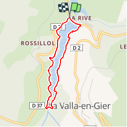

Length
3.2 km

Max alt
552 m

Uphill gradient
71 m
Km-Effort
4.2 km

Min alt
494 m

Downhill gradient
85 m
Boucle
Yes
Creation date :
2019-03-12 08:39:32.26
Updated on :
2019-03-12 09:07:33.797
27m
Difficulty : Very easy

FREE GPS app for hiking
 SityTrail
IGN / Geographical institutes
SityTrail Plus
The world is yours!
About
Trail Running of 3.2 km to be discovered at Auvergne-Rhône-Alpes, Loire, La Valla-en-Gier. This trail is proposed by Martinechampailler.
Positioning
Country:
France
Region :
Auvergne-Rhône-Alpes
Department/Province :
Loire
Municipality :
La Valla-en-Gier
Location:
Unknown
Start:(Dec)
Start:(UTM)
618465 ; 5031467 (31T) N.
Comments